You have half an hour, your shoes are by the door, and you head out. Three blocks later you're at the same intersection as yesterday, turning left again. Nothing wrong with that: a familiar loop makes it easy to get going. But if you want to build up, add some variety, or run somewhere new, a route you've chosen on purpose helps.
This article is for beginner and recreational runners who want to know what makes a good running route. You'll learn how to settle on a distance, when a loop or an out-and-back works best, what surface, green space, and elevation do to your run, and what to watch for in traffic and after dark. Then you'll see how to plan a running route in a few clicks and get it onto your watch.
01 · DistanceHow long should your running route be?
Start with the workout you want to do, not with the map. Many beginner programs use minutes instead of distance, and that's a comfortable place to start: you run easy for half an hour, and the distance follows.
If you do want to know how long your route should be, multiply your time by your usual pace. At an easy 7:00 min / km11:16 min / mi, thirty minutes takes you about 4.3 km2.7 mi. At 6:00 min / km9:39 min / mi, forty-five minutes is roughly 7.5 km4.7 mi. The pace calculator works this out for your own pace.
A few rules of thumb by workout:
If you follow a personal training plan, every workout already tells you how long or how far to run. Further down, you'll see how to attach a route to a workout directly.
02 · Loop or out-and-backLoop or out-and-back?
A loop feels like a proper outing: you keep seeing something new and finish where you started. An out-and-back (you run out, turn around, and come back the same way) is often underrated, but it has a few clear advantages for beginners:
A third option is a short loop of, say, 2 km1.2 mi around your home that you run a few times. It's less varied, but you keep passing your front door for water, an extra layer, or a restroom stop. That works well for your first runs or a short interval session.
03 · SurfaceSurface: pavement, paths, or trails
The surface shapes how your run feels and how smoothly you can keep going.
Whether a softer surface prevents injuries isn't clearly established. Choose what feels comfortable and feel free to mix it up. If you run off-road a lot, read how to choose running shoes with a tread that suits the terrain.
04Green space and water
A route through a park, along a river, or through the woods feels calmer to many people than a loop along busy streets. There's usually less traffic and fewer lights, and more to look at. If you run to clear your head, a route like that can help; running for stress relief covers easy running for relaxation in more detail.
Keep two things in mind. Open water and exposed embankments are often windier, which makes an easy run harder. And parks and trails are usually unlit at night. A green route that's perfect in daylight may not be your best choice on a November evening.
05 · ElevationFlat or hilly?
Even a few short climbs can make an easy run harder than you expect. On a hill, your effort goes up at the same pace, so slow down on the way up and let your breathing guide you. In flat areas, bridges, overpasses, and embankments are often the only "hills," and they count too.
For easy runs and your first weeks, a flat route keeps your effort steady. If you want to build strength and running skill, a few hills make a good addition. The article on running faster explains how to dose hill training, including using bridges as hills.
A route planner shows the total elevation gain and an elevation profile. That way you can see in advance where the climb is and whether it comes at the start or the end of your run.
06 · SafetyStaying safe: traffic, crossings, and the dark
Traffic and crossings
Every busy crossing is a moment where you stop or need to pay close attention. Especially for intervals, pick a route with as few busy intersections as possible. A detour through an underpass or a quiet side street is often quicker than waiting at a light.
Use the sidewalk where there is one. Where there isn't, a common piece of safety advice is to run facing traffic, so you can see cars coming toward you. Local rules differ, so check what applies where you run. Never assume a driver has seen you, and keep your music low enough to hear traffic.
Running in the dark
In fall and winter, part of your training will likely happen in the dark. Choose a route with streetlights and a sidewalk or lit bike path where you can. Unlit paths are fine with a good headlamp, but less suitable on a stretch you don't know.
Being visible makes a big difference. According to the Dutch motoring association ANWB, drivers see a pedestrian in dark clothing only at about 20 meters (65 feet), in light clothing at about 50 meters (165 feet), and reflective materials can get you noticed up to 150 meters (about 500 feet) sooner. The article on winter clothing covers staying visible in the dark, and you'll find more on a headlamp and reflective gear among the running accessories.
Keep in mind that a route planner doesn't know whether a path is lit, whether a park feels comfortable at night, or whether there's construction. Try a new route in daylight first if you can, or check it in satellite view to see which buildings and paths it passes.
Let someone know where you're running
If you run alone, especially on a new or remote route, tell someone which route you're taking and roughly when you'll be back. You can share a saved route as a link. If you share a route publicly, for example in a club chat, keep in mind that a loop starting at your front door shows where you live. If you often run alone, vary your routes and times, too.
07 · Water and restroomsDrinking water and restrooms
For an easy run of half an hour to an hour, you usually don't need a water stop. On longer runs or in warm weather, it helps if your route passes water. Plan it past your home, a public fountain, or a place where you can buy a drink. How much you need is covered in hydration during hot runs.
The RunCulture route planner shows public drinking water points within about 50 meters (165 feet) of your route, based on OpenStreetMap. Don't rely on them blindly: a fountain can be broken or moved, and many are shut off in winter to prevent freezing. Always bring your own water on long or hot runs.
Restrooms are harder to plan. Train stations, sports fields, gas stations, and cafés along the way are the obvious options, and a short loop past your home solves it altogether.
08 · VarietyVariety: not the same loop every day
A regular route is handy: you don't have to think, and you can see your progress on a familiar course. But the same loop every time can get dull, and new surroundings often make a run feel lighter.
A few ways to mix things up without searching from scratch every time:
If bad weather keeps you indoors, the tips in motivation in bad weather can help.
09 · Somewhere newFinding a route somewhere new
On vacation or a work trip, you don't know which streets are pleasant to run. Ask at your hotel, or see whether there's a running club nearby that runs together. Do your first run in daylight and make it an out-and-back from your hotel, so you can always find your way back.
A route planner can suggest a loop of the right distance before you go. Then check the route in satellite view to see whether it runs along a beach, through a park, or next to a busy road. For more on routines, gear, and safety abroad, read running while traveling.
10 · Route plannerHow to plan a route with the RunCulture route planner
With the free RunCulture route planner, you can plan a running route of any distance, from a short loop to a long run, anywhere in the world. You don't need an account.
Starting point and distance
Search for a street or place, use your current location, or click the map. Then pick a distance and click Generate routes. The planner suggests loops that stay within a few percent of your distance. If none of them feel right, click Generate route to add a new one.
Route preferences: a direction, not a guarantee
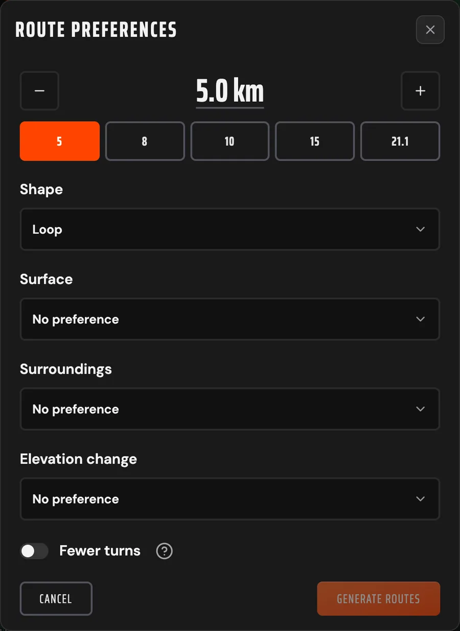
Once you have a suggestion, the button with the sliders next to Generate route opens the route preferences. There you choose:
Think of the preferences as a direction. The planner looks for loops that match as closely as possible, but it can't create what isn't there. If there's little green space nearby, you'll see a note that this is the greenest loop it found.
Reading a suggestion
Each suggestion shows what share of the route runs on paths, through green space, and along water. For the selected route, you also see the share of streets and unpaved ground, the estimated running time, and the elevation gain with an elevation profile. The map shows distance markers. In the layers menu you can turn on the running direction and the drinking water on the route, among other things, and the Satellite button shows the route on aerial imagery.
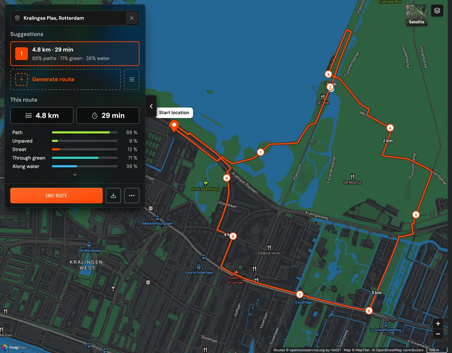
The information comes from open map data maintained by a worldwide community. It's a good indication, but not a guarantee: a path can be closed or look different from what the map says.
Drawing or adjusting a route
If you already know where you want to go, choose Draw yourself and click points on the map. The route automatically follows paths and streets. You can adjust a generated suggestion the same way by dragging its points, for example to avoid a busy crossing.
Saving and sharing
A saved route gets its own page with a permanent link that you can send to a running buddy or your club. For a loop, you can turn on Hide start point when saving: the route stays visible, but your exact starting point doesn't. Saving works without an account; add your email address and you can link the route to your account later.
11 · Route on your watchGetting the route onto your watch
A route on your watch is handy somewhere new: you see the line and don't have to keep pulling out your phone. Most sports watches can import a GPX file. In the route planner, click Download GPX and import the file into your watch's app as a course. The exact steps differ by brand. To see what else a watch can do for you on the run, read about wearables for runners.
If you have a Garmin, it takes one step. Connect your Garmin Connect™ account in your profile, then choose Send to Garmin Connect™ from the … menu of a saved route. The route arrives in Garmin Connect™ as a course, with drinking water points along the route as water stops. After your watch syncs, you'll find it under Navigation > Courses. Read more in your route, straight to your Garmin watch.
12 · Attach to your planAttaching routes to your training plan
If you follow a RunCulture personal training plan, every workout has a Route button. The planner then uses that workout's distance right away, and you choose a saved route or plan a new one. The step-by-step version is in attaching a route to a workout. If you sync your plan with Garmin Connect™, routes attached to workouts in the next 14 days can go along automatically as courses.